


GILLIAM, Jasper County, Indiana
About
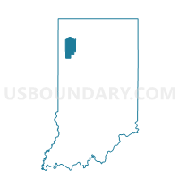
Outline

Summary
| Unique Area Identifier | 577957 |
| Name | GILLIAM |
| County | Jasper County |
| State | Indiana |
| Area (square miles) | 38.23 |
| Land Area (square miles) | 38.23 |
| Water Area (square miles) | 0.00 |
| % of Land Area | 100.00 |
| % of Water Area | 0.00 |
| Latitude of the Internal Point | 41.05405190 |
| Longtitude of the Internal Point | -86.96607020 |
Maps


Graphs
Select a template below for downloading or customizing gragh for GILLIAM, Jasper County, Indiana


Neighbors
Neighoring Voting District (by Name) Neighboring Voting District on the Map
- BARKLEY NORTH, Jasper County, IN
- BARLEY SOUTH, Jasper County, IN
- CASS, Pulaski County, IN
- HANGING GROVE, Jasper County, IN
- SALEM, Pulaski County, IN
- WALKER EAST, Jasper County, IN
- WHITE POST, Pulaski County, IN
Top 10 Neighboring County Subdivision (by Population) Neighboring County Subdivision on the Map
- Walker township, Jasper County, IN (3,663)
- Salem township, Pulaski County, IN (1,399)
- White Post township, Pulaski County, IN (1,075)
- Barkley township, Jasper County, IN (900)
- Cass township, Pulaski County, IN (878)
- Gillam township, Jasper County, IN (640)
- Hanging Grove township, Jasper County, IN (230)
Top 10 Neighboring Unified School District (by Population) Neighboring Unified School District on the Map
- Kankakee Valley School Corporation, IN (20,162)
- Rensselaer Central School Corporation, IN (10,723)
- West Central School Corporation, IN (4,716)
Top 10 Neighboring State Legislative District Lower Chamber (by Population) Neighboring State Legislative District Lower Chamber on the Map
Top 10 Neighboring State Legislative District Upper Chamber (by Population) Neighboring State Legislative District Upper Chamber on the Map
- State Senate District 5, IN (127,561)
- State Senate District 7, IN (124,746)
- State Senate District 18, IN (118,690)
Top 10 Neighboring 111th Congressional District (by Population) Neighboring 111th Congressional District on the Map
Top 10 Neighboring Census Tract (by Population) Neighboring Census Tract on the Map
- Census Tract 1008, Jasper County, IN (5,037)
- Census Tract 1012, Jasper County, IN (3,944)
- Census Tract 9591, Pulaski County, IN (3,784)
- Census Tract 9592, Pulaski County, IN (3,209)